Kata Tjuta
Introduction of Kata Tjuta
Kata Tjuta (Kata Tjuta, also known as Mount Olga) is located in Uluru-Kata Tjuta National Park, inland in the southern part of the Northern Territory, about 460 kilometers from Alice Springs, the nearest major city, about 460 kilometers from Alice Springs, the northern-lying capital, Darwin, about 1960 kilometers away.
Urulu-Kata Tjuta National Park has specialized airports: Ayers Rock Airport (airport code: AYQ), direct flights from Melbourne, Sydney, Alice Springs, Cairns, and expensive airfares to Ayers Rock for reasons of monopoly and remoteness, with car rentals such as Herz and Avis.
Kata Tjuta, along with Uluru, also known as Ayers Rock, known as the "Red Heart of Australia," formed the Uuru-Kata Tjuta National Park, which was the entire national park in 1987 Common UNESCO selected as the world's natural and cultural heritage.
In the language of the local Pitjantjatjara, Kata Tjuta means "long land," which is the best illustration of the peculiarly extraordinary rock shape here.
Kata Tjuta, covering an area of about 40 sq km, is a monolithic complex of 36 dome stones of varying sizes and height, the highest named Mount Olga,1066 metres above sea level and 546 metres above the ground, named by explorer Ernest Giles in memory of the Fort Futenburg Queen Olga.
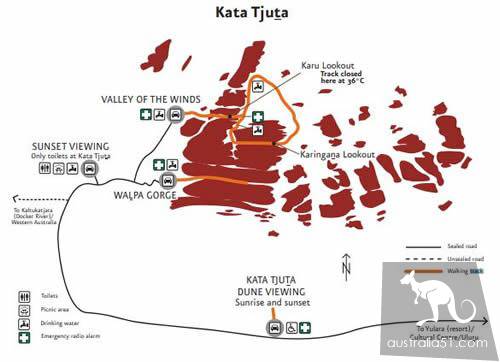
The main way to visit Kata Tjuta is to have access to the interior of Kata Tjuta via two hiking routes, in addition to the two main viewing areas of Kata Tjuta Shachu View Area and Kata Tjuta Sunset View Area.
Kata Tjuta hiking road map, click on the picture to see the big picture
As can be seen from the footpath map above, the two walkways can only walk into the boulder section of the preceding section, because most of the area of Kata Tjuta is classified as inaccessible, and visitors must walk within the planned walkway to avoid danger for their own safety.
Two hiking routes:
- Wapa Gorge:
- Round trip 2.6 km, about 1 hour
- There are no trees to shade this route, so if it's too late to leave it will be very hot, please go there at your own time
Valley of the Wind:
- Round trip 7.4 km, about 4 hours
- The Valley of the Wind is a more popular trail, and officials say it's tough because it's a long journey that requires physical strength. It's recommended to leave early in the summer to avoid getting too sunburnt
- In fact, it can be subdivided into two feeder lines: the Karu Lookout route (2.2 km round trip) and the Karingana Lookout route (5.4 km round trip), where physically strong visitors can challenge the entire 7.4 km loop
- Note: After 11:00, and when the temperature exceeds 36°C, the trail behind the Caruview is closed
Tickets:
Uluru-Katachuta National Park Tickets: A $25 adults, children (age 5-15): A $12.5 family (size 2): A $65 for repeated access within three days
Open time:
- 12、1、2月:5am - 9pm3月:5.30am - 8.30pm4月:5.30am - 8pm5月:6am - 7.30pm6、7月:6.30am - 7.30pm8月:6am - 7.30pm9月:5.30am - 7.30pm10月:5am - 8pm11月:5am - 8.30pm
