卡塔丘塔(Kata Tjuta,又称奥尔加山 Mount Olga)位于北领地南部内陆的乌鲁鲁-卡塔丘塔国家公园(Uluru-Kata Tjuta National Park),距离最近的大城市是约460公里车程的北领地城市爱丽丝泉(Alice Springs),距离北领地首府达尔文(Darwin)约1960公里车程。
乌鲁鲁-卡塔丘塔国家公园有专门的机场:艾尔斯岩机场(Ayers Rock Airport,机场代号:AYQ),从墨尔本(Melbourne)、悉尼(Sydney)、爱丽丝泉、凯恩斯(Cairns)有直达航班,因垄断及地处偏远等原因,飞往艾尔斯岩机场的机票都很贵,机场有Herz、AVIS等租车公司提供租车。
卡塔丘塔和有“澳大利亚的红色心脏”之称的乌鲁鲁(Uluru,也称艾尔斯岩 Ayers Rock)一起组成了乌鲁鲁-卡塔丘塔国家公园,而整个国家公园在1987年被联合国教科文组织评选为世界自然文化遗产。
在当地皮善朱拉(Pitjantjatjara)的语言中,卡塔丘塔的意思是指“多头之地”,这是此处奇特超凡的岩石形态最好的写照。
卡塔丘塔占地约40平方公里,是由36块大小不一,高低不等的圆顶石头组成的巨石阵,最高的点名为奥尔加山(Mount Olga),海拔1066米,距地面高度546米,这是探险家欧内斯特·盖尔斯(Ernest Giles)为了纪念符腾堡皇后奥尔加(Olga)而命名的。
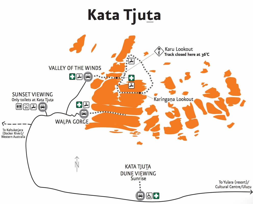
游览卡塔丘塔的主要方式,除了在卡塔丘塔沙丘观景区(Kata Tjuta Dunes Viewing Area)和卡塔丘塔日落观景区(Kata Tjuta Sunset View Area)两个主要的观景区欣赏日出日落和拍照外,还可以通过两条徒步路线进入卡塔丘塔内部。
卡塔丘塔徒步路线地图,点击图片可以查看大图
从上面的徒步路线地图可以看的出来,这两条步道仅能走进前段的巨石段,这是因为卡塔丘塔的大部分区域是被列为圣地不可进入的,而游客为了本身安全,必须走在规划的步道内,以免发生危险。
两条徒步线路介绍:
瓦帕峡谷(Walpa Gorge):
往返2.6公里,需约1小时
这条路线没有树木可以遮阳,所以如果太晚出发会很热,请自行针酌时间前往
风之谷(Valley of the Winds):
往返7.4公里,需约4小时
风之谷是更受欢迎的步道,官方显示这条步道等级为艰难,因为路程较长需要体力,夏天时建议早点出发,避免太晒
其实又可以细分为两条支线:卡鲁观景台(Karu Lookout)路线(2.2公里往返)以及卡林加娜观景台(Karingana Lookout)路线(5.4公里往返),体力充沛的游客可以挑战整个7.4公里的环路
注意:11点以后,以及温度超过36°C时,卡鲁观景台之后的步道是不开放的
