Google Maps is now offering new features to help users travel safely during the epidemic. More than 11 million people worldwide have been infected with the new crown, with 500,000 death., according to Johns Hopkins University (Johns Hopkins University)
Because different countries and regions have issued different restrictions according to the severity of the epidemic, this makes people's travel complicated. At a news conference in June, Google Maps product management director Galayan (Ramesh Nagarajan) said :" New crown pneumonia definitely affects how we move around the world. "Google Maps is collecting data from local and national institutions and government and reminding users of relevant information to help travelers.
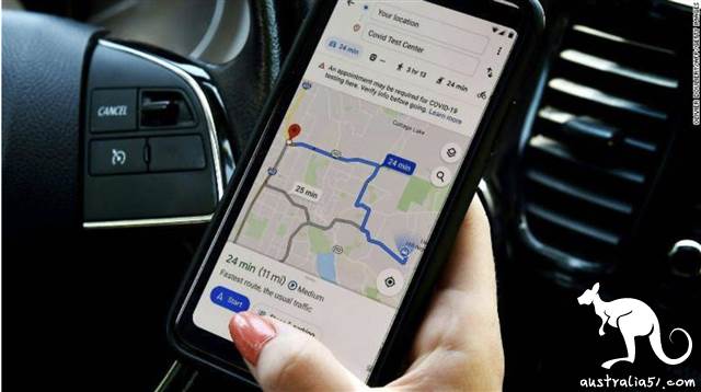
Here are some new features that users can expect: restricted alerts google maps users will receive driving alerts, new coronal pneumonia checkpoints they have when crossing the border, and restrictions along the road. If drivers enter areas affected by certain restrictions such as mask enforcement or social distance regulations, they will see warnings on the navigation screen. Checkpoints and restriction alerts are currently available in Canada, Mexico and the United States. The test alert Nagarajan said that when someone drives to a medical facility or a coronary virus testing center, they will be alerted to the relevant guidelines "to avoid being shut out or putting additional pressure on the local medical system ".
Indonesia, Israel, the Philippines, South Korea and the United States all have warnings for medical facilities. public transport alert when using google maps to navigate public transport in areas affected by new crown pneumonia, travelers will receive alerts from local transportation agencies to alert them to regulations such as mask requirements or whether government orders affect transport services.
Argentina, Australia, Belgium, Brazil, Colombia, France, India, Mexico, the Netherlands, Spain, Thailand, the United Kingdom and the United States are launching transit alerts. Google Maps introduced congestion predictions for public transport in 2019, using millions of messages provided by passengers to show people how crowded bus lines or train are. now it is easier for people to submit their own crowding experience and check how busy they are about to take train or buses. This will help commuters avoid crowded rides and plan to travel during less busy times, thereby maintaining social distance.

